GCI30: a global dataset of 30-m cropping intensity using multisource remote sensing imagery
Global cropping intensity
Type
Publication
Earth System Science Data
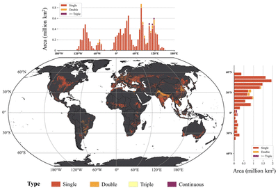
Cropping intensity (CI) is essential for agricultural land use management but fine resolution global CI is not available.
Here, we develop the first product of 30 m resolution Global CI (GCI30).
- Overall accuracy: 92%
- Implication: sustained agricultural intensification